WILDLAND FIRE AIR QUALITY TOOLS PORTAL
TOOL ACCESS
|
ABOUT THIS SITE
|
HELP
|
CONTACT
Wildland Fire Air Quality Tools
WFDSS Integrated Tools v0.9 (Beta Test)
STATUS:
IMPORTANT UPDATE 2/6/13 :
THIS PAGE IS BEING REDESIGNED AND REIMPLEMENTED FOR THE 2013 WESTERN WILDFIRE SEASON.
SOME FEATURES AND LINKS MAY BE BROKEN IN THE MEANTIME.
WE APOLOGIZE FOR THE INCONVENENCE.
STEP 1
Set your fire location:
location used for tailored products.
Latitude
°N
Longitude
°E
STEP 2
Select Your Tool:
Smoke Guidance Point Forecast
Smoke Guidance Regional Maps
Diurnal Surface Wind Pattern Analysis
Climatological Ventilation Index Point Statistics
Current Air Quality Conditions Map
Fire Information & Smoke Trajectories
Customized Fuels, Consumption, & Smoke Modeling
See below for tool description, attributes, and other details.
Filter by:
ATTRIBUTE
[any]
Instant Access
Easy to Use
Localized
Text-based
Graphical
Interactive
FORECAST PERIOD
[any]
Uses Climatological Data
Shows Current Conditions
1 Day + Forecast
3 Day + Forecast
7 Day + Forecast
Tool List
Current filter applied: 7+ DAY FORECAST tools only
(remove filter)
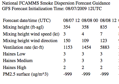
Smoke Guidance Point Forecast
localized text summary of atmospheric conditions affecting smoke
produced by: National FCAMMS
Predicted conditions at your location affecting fire and smoke.
Mixing Height
Transport Winds
Ventilations Index
Haines Index
National Scope
7 day Point Location Forecast
Uses National Weather Service NAM and GFS weather predictions
ATTRIBUTES
INSTANT ACCESS
EASY TO USE
๏ LOCALIZED
text
☼ ➳ ATMOSPHERIC CONDITIONS
GFS (7-day) forecast
learn more
CREATED IN PARTNERSHIP WITH